Snow/Sleet Starts Off Weekend| 06:38PM / Friday, March 22, 2024 | |
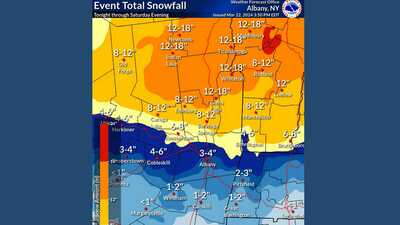
It may be spring but winter isn't quite done with us. This week's drop in temperatures and flurries are being followed by a more significant storm that could drop 2 to 6 inches over the region this weekend.
A winter weather advisory is in effect beginning at 11 p.m. on Friday through 11 p.m. Saturday for Berkshire County, Southern Vermont and eastern New York.
The National Weather Service in Albany, N.Y., says be prepared for gusty winds and icy roads on the morrow as snow turns to freezing rain on Saturday.
These periods of rain and sleet will turn back to snow by Saturday evening and snowfall rates may get close to one inch per hour late Saturday before precipitation ends. Areas to south and east may see flooding as more than 3 inches of rain is expected to fall along the Atlantic Coast, according to Accuweather.
Up to 18 inches of snow could fall across upstate New York and central Vermont but North Berkshire looks to get 2 to 3 inches, with the potential for 4 to 6 along the Vermont border. Southern Berkshire could see 1 to 2 inches of snow that could turn to fully to rain/sleet.
A reminder that most parking bans are still in place until at least March 31. Also, Thunderfest in Adams has been postponed to Sunday, March 24.
| 
 MEMBER SIGN IN